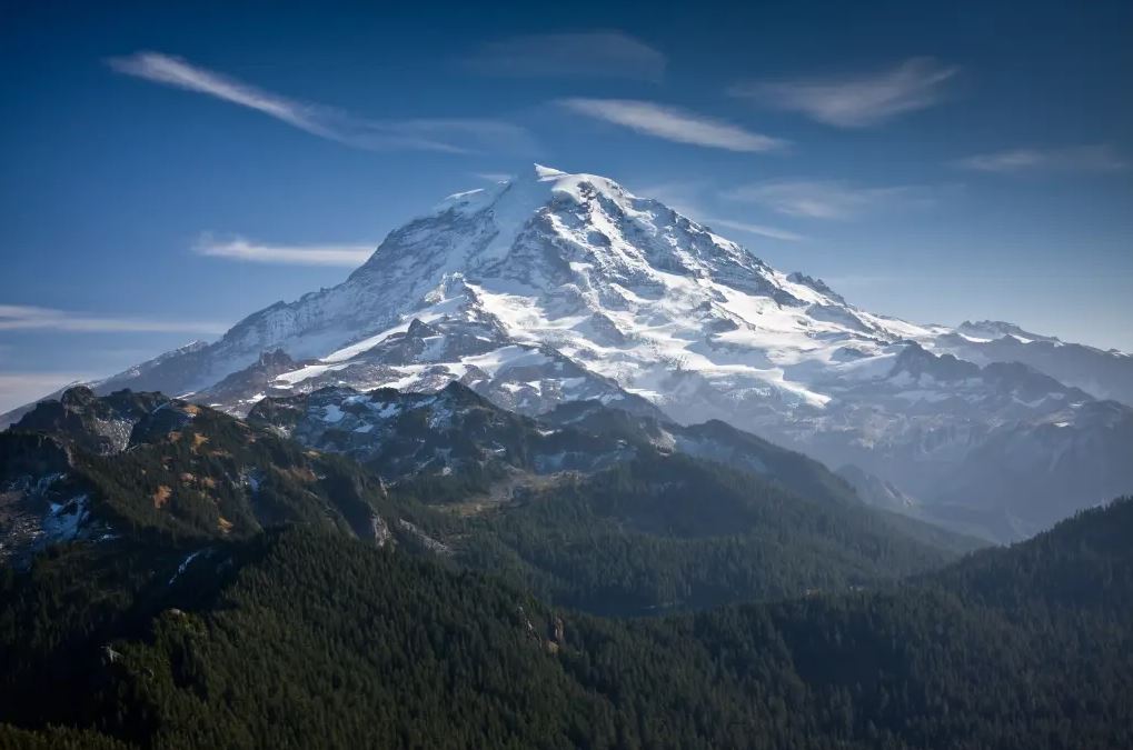
Mount Rainier looks peaceful from Seattle on a clear day. It sits on the horizon, white and enormous, like a postcard of the Pacific Northwest. What most people driving past it do not know is that it is one of the most dangerous volcanoes on Earth. Not because it is about to erupt. But because of what would come down its slopes if it did.
What Is a Lahar?
A lahar is a volcanic mudflow. The word comes from Javanese. It describes what happens when volcanic material, water, ice, and debris mix and move together at high speed down a mountain's river valleys. It looks like wet concrete. It moves like a flood. It buries everything in its path.
Lahars do not need a full eruption to start. A large earthquake, a sudden collapse of the volcano's ice-covered summit, or even heavy rainfall on loose volcanic material can trigger one. Mount Rainier sits under more glacial ice than any other peak in the contiguous United States. That ice is the fuel.
When that ice melts fast, the water has nowhere to go but down. It picks up volcanic rock, ash, soil, and forest debris as it moves. By the time it reaches the river valleys below, it is no longer water. It is a moving wall of mud and rock that buries roads, buildings, and people under meters of material.
When Did Mount Rainier First Become Active?
Mount Rainier began forming roughly 500,000 years ago through repeated volcanic eruptions. It is a stratovolcano, built up over hundreds of thousands of years from layers of lava, ash, and volcanic debris. Its cone grew to become the highest peak in the Cascade Range, rising to 4,392 meters above sea level.
The mountain sits above a subduction zone where the Juan de Fuca tectonic plate slides beneath the North American plate. That slow, grinding subduction is the engine behind all volcanic activity in the Cascades, including Mount St. Helens, Mount Hood, and Glacier Peak.
Full Timeline of Mount Rainier's Volcanic History
500,000 Years Ago, Mount Rainier begins forming. Early eruptions build the base structure of the volcanic cone through repeated lava flows and explosive events.
100,000 to 50,000 Years Ago Multiple major eruption cycles reshape the cone. Lava flows extend many kilometers from the summit. The volcano reaches close to its current height during this period.
5,600 Years Ago: The Osceola Mudflow. This is the most significant event in Mount Rainier's recorded geological history. A massive collapse of the volcano's summit, combined with volcanic activity, triggered the largest known lahar from any North American volcano. The Osceola Mudflow traveled over 110 kilometers from the summit, reaching all the way to Puget Sound. It buried an area now occupied by the cities of Auburn, Kent, Sumner, and Puyallup under up to 30 meters of volcanic debris. The volume of material moved was staggering. The entire region around modern-day Puget Sound lowlands sits on top of the remnants of this single event.
2,500 Years Ago: A period of renewed volcanic activity produced lava flows, ash falls, and smaller lahar events. These events reshaped the upper slopes and deposited fresh volcanic material across river valleys to the south and east of the summit.
500 Years Ago: The Electron Mudflow. A large lahar traveled down the Puyallup River valley without any confirmed major eruption triggering it. Geologists believe a sudden collapse of waterlogged volcanic rock on the volcano's flank was the cause. The Electron Mudflow reached the lowlands of Pierce County, burying the valley floor under several meters of debris. The town of Orting, Washington, which today has around 10,000 residents, sits directly on top of this deposit.
1820 to 1894: Recorded Minor Eruptive Activity. Early European settlers and explorers documented steam emissions, minor ash events, and apparent small eruptions from Mount Rainier's summit area during this period. The most recent confirmed minor eruptive activity occurred in 1894, when observers noted steam and possible ash plumes from the summit crater. No significant lahars accompanied these events.
1980: Mount St. Helens Eruption Changes Everything. While not a Rainier event, the catastrophic eruption of Mount St. Helens 150 kilometers to the south on May 18, 1980, fundamentally changed how volcanologists assessed Cascade volcano risks. It killed 57 people, generated massive lahars, and demonstrated exactly how quickly a volcanic event can overtake populated valleys. It prompted an intensive new study of Mount Rainier's lahar hazards and the populations living in its river valleys.
1998: USGS Lahar Hazard Maps Published. The United States Geological Survey published detailed lahar inundation maps for Mount Rainier's surrounding valleys. These maps identified specific communities at risk and the timeframes residents would have to evacuate. The findings alarmed emergency managers. Orting had approximately 20 minutes of warning time between a lahar reaching certain sensor points and the mud arriving in town.
2000s to 2020s: Warning System Installation. A network of acoustic flow monitors and sensors was installed in river valleys surrounding the volcano. These devices detect the ground vibrations and acoustic signatures that lahars produce. They are designed to give downstream communities maximum warning time. The system has been upgraded multiple times.
2026: Present Status Mount Rainier remains classified as dormant but not extinct. The USGS Cascades Volcano Observatory monitors it continuously for seismic activity, ground deformation, gas emissions, and hydrological changes. No current eruption is anticipated. But volcanologists are clear: the question is not whether a major lahar will come from Mount Rainier. The question is when.
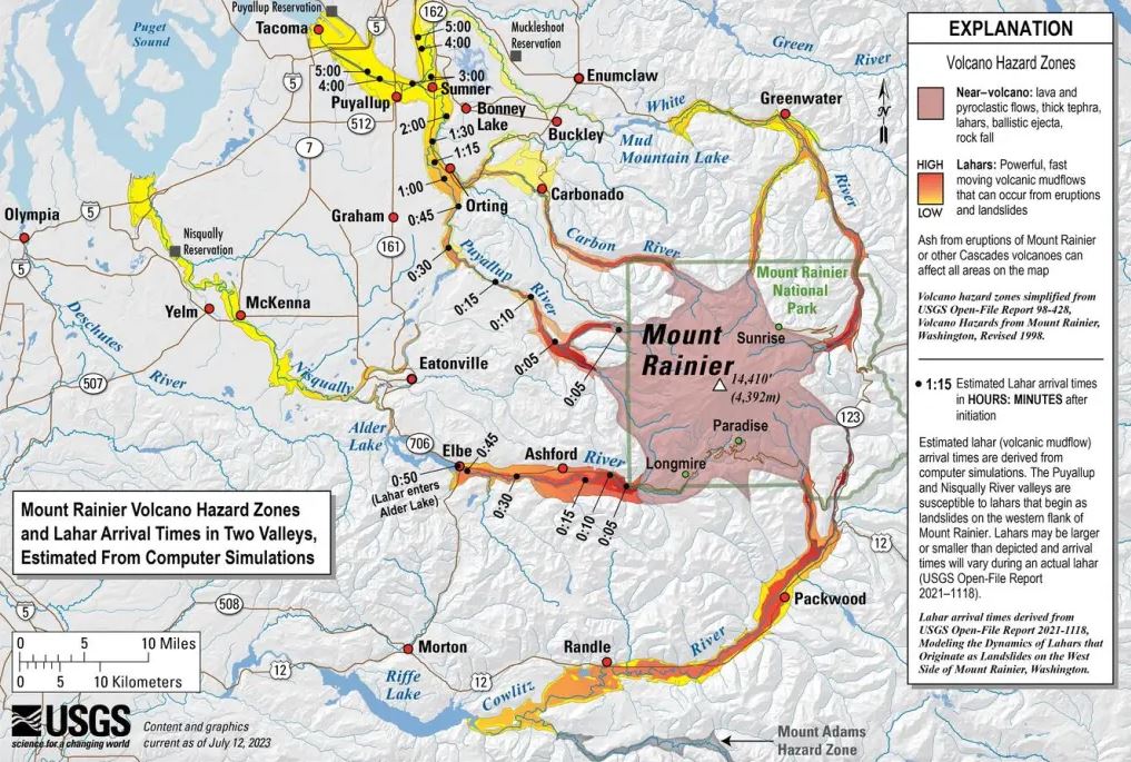
How Many People Are in the Hazard Zone
This is where the numbers become alarming. Approximately 150,000 people live in the lahar inundation zones mapped around Mount Rainier's river valleys. These are not theoretical risk zones on a map that nobody uses. They are populated communities with homes, schools, hospitals, and businesses built directly in the paths that lahars from previous centuries already traveled.
The primary valleys at risk are the Puyallup River valley, the Carbon River valley, the Nisqually River valley, the White River valley, and the Cowlitz River valley. Each of these drains a different side of the mountain. A lahar following any of them would reach populated areas within minutes to hours, depending on the valley.
Orting, Washington, faces the most acute risk. The town sits in the Puyallup River valley at the base of the mountain. It has around 10,000 residents. It has two bridges as evacuation routes. In the event of a major lahar, researchers estimate residents have between 30 and 40 minutes to reach high ground before the flow arrives. Children in Orting's schools practice lahar evacuation drills. There are marked walking routes to elevated terrain.
Sumner and Puyallup are larger communities downstream with combined populations of over 50,000 people. They have more time than Orting but face the same threat. The lahar would arrive carrying more debris and with a wider flow width as it spreads into the lowlands.
Auburn, Kent, and Renton sit on ancient lahar deposits from the Osceola event. A repeat of an Osceola-scale event would threaten all of them. Their combined populations exceed 200,000 people.
Tacoma has critical infrastructure in the lahar inundation zone, including industrial facilities, transportation corridors, and port operations.
Historical Deaths and Damage from Cascades Volcanic Events
Mount Rainier itself has not produced a deadly lahar in recorded human history. The last major lahars predate European settlement in the region. There are no documented death tolls from Rainier's geological past events because no population lived in these valleys when those events occurred.
However, Cascade Range volcanic history provides stark reference points.
The 1980 Mount St. Helens eruption killed 57 people directly. Lahars from that event traveled 27 kilometers down the Toutle River valley, destroying over 200 homes, 47 bridges, and 300 kilometers of roads. The economic damage exceeded $1 billion in 1980 dollars.
Globally, lahar events have killed tens of thousands of people. The 1985 eruption of Nevado del Ruiz in Colombia produced lahars that buried the town of Armero. Over 23,000 people died. The lahar gave less than 10 minutes of warning. Most victims were asleep when the flow arrived. That event became the defining case study in lahar disaster risk management worldwide.
Volcanologists use Armero as a baseline warning for what could happen in the Puyallup River valley if a major Rainier lahar occurs during nighttime hours or outside normal school and work schedules when fewer people are in a position to evacuate.
Why Rainier's Lahar Risk Is Unique?
Three factors combine to make Mount Rainier's lahar hazard different from almost any other volcano on Earth.
First, the ice volume. Mount Rainier has 26 named glaciers covering approximately 90 square kilometers of its surface. The total ice volume is estimated at over four cubic kilometers. This is the largest glacial system on any single peak in the contiguous United States. When volcanic heat, hydrothermal fluids, or a structural collapse meets that much ice, the resulting water volume is enormous.
Second, the population density. Most dangerous volcanoes on Earth are in remote areas. Mount Rainier sits within 100 kilometers of Seattle and Tacoma, a combined metro area of over four million people. The valleys immediately below the volcano are not wilderness. They are suburbs, farms, and industrial zones.
Third, the hydrothermal alteration. Decades of volcanic gases and heated groundwater have chemically weakened the rock inside Mount Rainier's volcanic cone. This process, called hydrothermal alteration, converts solid rock into soft clay-like minerals that cannot support the weight above them. Large sections of the volcano's interior are structurally compromised. A significant earthquake or a shift in volcanic activity could trigger a collapse of this weakened material without any visible warning at the surface.
Current Preparedness and Warning Systems
Washington State and Pierce County have invested significantly in lahar preparedness. Evacuation routes are marked. Schools run drills. Emergency managers have established protocols. The acoustic flow monitoring network provides real-time data.
But researchers and emergency planners are honest about the limitations. Thirty to forty minutes is not much time to evacuate a town of 10,000 people over two bridges. Traffic congestion alone could prevent many residents from reaching high ground in time. People with disabilities, elderly residents, and families with small children face compounded challenges.
Current plans focus on vertical evacuation structures, elevated concrete platforms built within the inundation zone where people who cannot flee can climb above the lahar's expected depth. These structures are controversial. Some engineers argue they offer false security. Others argue they are the only realistic option for residents who cannot drive to high ground in time.