India's southwest monsoon has stumbled badly this season. As of late June 2026, the country is staring at one of its weakest monsoon starts in over a century, and the numbers explain why farmers, water managers, and city planners are watching the skies with growing unease.
Current Rainfall Status Across India
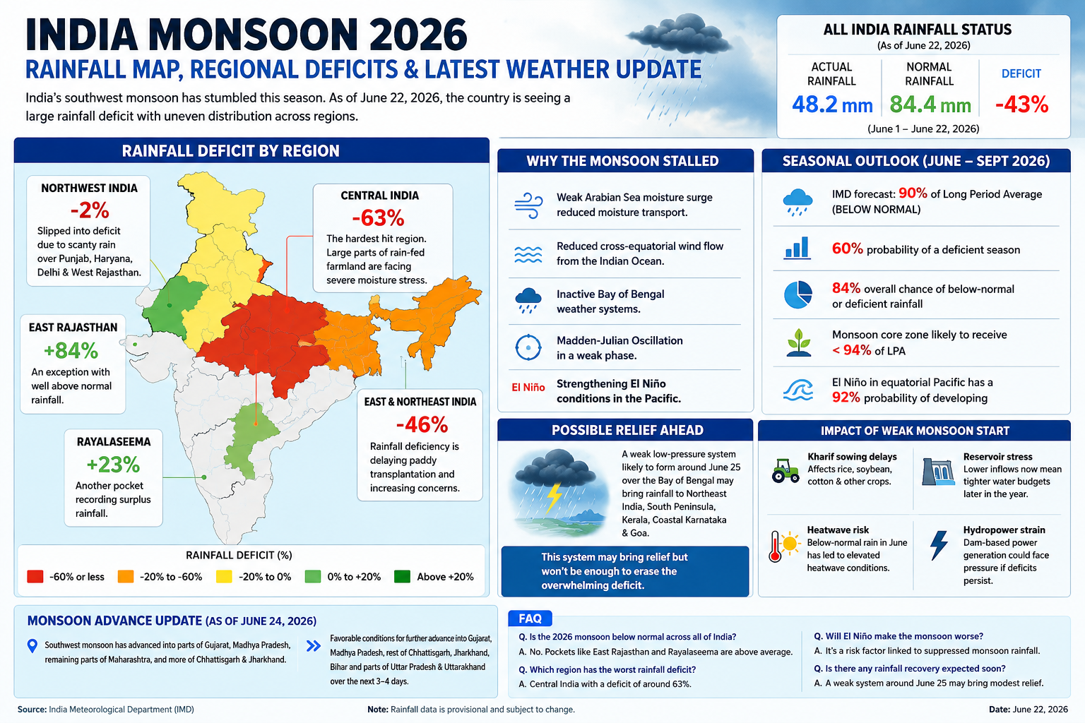
The India Meteorological Department's data paint a stark picture. India received only 45.6 mm of rainfall by June 20 against a normal of 84.4 mm, a deficit of 46 percent. By June 22, the all-India shortfall had narrowed slightly to around 43 percent, but the broader picture remains grim. Between June 1 and June 18, the countrywide deficit had already widened to 40 percent.
Why the Monsoon Stalled
IMD attributed the slowdown to weak low-level southwesterly winds over the Arabian Sea, reducing moisture transport toward Maharashtra and nearby interior regions. The cross-equatorial flow from the western Indian Ocean, a key moisture source, has also weakened in recent weeks. Add to that a sluggish Madden-Julian Oscillation and the developing El Niño pattern in the Pacific, and the system simply lost momentum.
Key factors behind the deficit:
- Weak Arabian Sea moisture surge.
- Reduced cross-equatorial wind flow.
- Inactive Bay of Bengal weather systems.
- MJO in a weak phase.
- Strengthening El Niño conditions.
Regional Rainfall Deficits: A State-by-State Breakdown
Rainfall distribution has been wildly uneven, and that unevenness is the real story this season.
Central India: The Hardest Hit
Central India remains the most rain-deficient region, with a shortfall of 63 percent. This zone covers much of the country's rain-fed farmland, so the shortage is already worrying agricultural officials ahead of kharif sowing.
East and Northeast India
East and Northeast India follow closely with a 46 percent deficit. States in this belt typically depend on early monsoon showers for paddy transplantation, and the delay is pushing that timeline back.
Northwest India: From Surplus to Shortfall
Northwest India was the only surplus region earlier in June, but has now slipped into deficit territory, currently standing at around 2 percent below normal. Scanty rainfall over Punjab, Haryana, Delhi, and West Rajasthan in recent days erased the earlier surplus. Even so, pockets remain wet: East Rajasthan continues to record 84 percent surplus rainfall, and Rayalaseema is running 23 percent above normal.
Quick regional snapshot:
- Central India: -63 percent.
- East and Northeast India: -46 percent.
- Northwest India: roughly -2 percent overall.
- East Rajasthan: +84 percent (an exception).
- Rayalaseema: +23 percent (an exception).
Seasonal Forecast: What the Rest of Monsoon 2026 Looks Like
IMD's official long-range forecast, issued on May 29, pegs the 2026 season at 90 percent of the Long Period Average, classifying it as a below-normal monsoon. The agency put the probability of a deficient season at 60 percent, with an 84 percent overall chance of below-normal or deficient rainfall nationwide.
The monsoon core zone, which covers most of India's rain-fed agriculture, is also expected to stay below 94 percent of the LPA. That matters because this zone produces a large share of India's kharif crops, including pulses, oilseeds, and cotton.
El Niño conditions in the equatorial Pacific carry a 92 percent probability of developing, a pattern historically linked to suppressed monsoon rainfall over Asia.
Possible Relief on the Horizon
There is a glimmer of hope. A weak low-pressure system may form around June 25 over the Bay of Bengal, potentially reviving rainfall over Northeast India, the South Peninsula, Kerala, coastal Karnataka, and Goa. Forecasters caution this system won't be strong enough to erase the current deficit on its own.
Meanwhile, monsoon advance has continued in fits and starts. By June 24, the southwest monsoon had pushed into parts of Gujarat and Madhya Pradesh, the remaining parts of Maharashtra, and more of Chhattisgarh and Jharkhand. Conditions were favorable for further advance into Gujarat, Madhya Pradesh, the rest of Chhattisgarh, Jharkhand and Bihar, and parts of Uttar Pradesh and Uttarakhand over the following three to four days.
What This Means for Agriculture and Water Supply
A weak monsoon start has cascading effects:
- Kharif sowing delays: Rice, soybean, and cotton planting depends on timely, consistent rain.
- Reservoir stress: Lower inflows now mean tighter water budgets later in the year.
- Heatwave risk: Below-normal rainfall in June has coincided with elevated heatwave conditions in several states.
- Hydropower strain: Dam-based power generation could face pressure if deficits persist into July.